
The Cork Cycle Map features the city centre and surrounding suburbs. The map shows the best routes to popular destinations around the city. These include UCC, CIT, Kent Station, Bus Station, Fitzgerald’s Park, and further afield to Mahon Point, Douglas, Bishopstown and Blackpool. Routes are colour coded by road type, whether segregated, one way, shared with cars and buses, on a quiet road or a greenway.
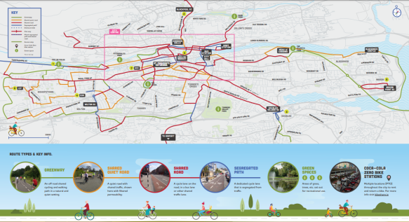
Metropolitian Area Cycle Map
The maps will help people navigate by bike to work, to school, or to the shops. For example, it only takes 20 minutes to cycle from the city centre to Mahon, most of which is on the picturesque Old Blackrock Railway line greenway. That sure beats sitting in traffic! The 8 greenway routes on the maps are ideal for a stress-free commute and are perfect places to bring the entire family out on a cycle.
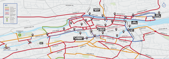
City Centre Cycle Map
Cycling has risen faster than any other transport mode in Cork over the last decade. It’s great fun: it saves you money, keeps you fit, is good for the environment and is often the fastest way to get around. It’s about the most effective action you can take to reduce your carbon emissions.

The maps were developed by the TMF and Cork Cycling Campaign with the support of Cork City Council and Healthy Ireland. They were launched for Bike Week 2019. The routes were suggested by regular cyclists based on segregation, quality and connectedness. While the quality of the city’s cycling infrastructure is variable, the past 5 years has seen significant improvements with more on the way. The maps will be updated as cycling infrastructure improves.
